GeoSync Technologies is committed to delivering cutting-edge tech solutions that empower businesses worldwide. With years of experience, our expert team crafts innovative products tailored to your needs.GIS Based Limited Liability Partnership, to provide consultancy services in the field of Geographic Information Systems (GIS), Software Development, project management, GIS data analysis, geospatial mapping, system analysis and design, software programming, spatial database management, software testing, and software quality assurance. The company shall also offer outsourcing services for GIS and software solutions, remote sensing applications, spatial modeling, and geospatial analytics to both international and domestic markets.
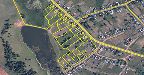
GeoSync Technologies is a geospatial and environmental intelligence company delivering data-driven solutions across Landscape & Natural Resource Management, Land Management, and Land Mapping. We integrate GIS, remote sensing, high-accuracy field surveys, survey & demarcation workflows, and digital platforms to support sustainable land use, ecosystem conservation, and climate-resilient development, while also enabling land administration and planning through precise spatial data. Our services extend to Crop Health Monitoring and Orchard Management, combining satellite-based analytics with ground verification to improve decision-making for agriculture and plantations. In addition, we develop Android applications for GPS-enabled field data collection, asset tracking, and reporting—bridging field realities with satellite intelligence to empower governments, development agencies, and environmental organizations to monitor, plan, and manage land and natural resources effectively.
Have questions or want to work with us? Reach out!
06/01, Habib Icon, Hirabad, Hyderabad
Mon - Fri: 9:00 AM - 6:00 PM